Sewage Pollution in Poole Harbour
Abstract: In August 2020 I wrote a series of blog entries about why I was getting ill so often from swimming in Poole Harbour. In early November Surfers Against Sewage released a report that stated that Shore Road Beach in Sandbanks has the most polluted bathing water in the country, its waters accepting 10% of the sewage discharges in England and Wales. This article is a compilation of all the data and links that point to how this has escaped general knowledge to date and what can be done to improve the situation.
BeachPeople has a range of memberships ideal for Sandbanks locals to city-stranded ocean spirits who just want to connect, especially in the seemingly endless UK winters. But our big drive is to stop the raw sewage pollution of Poole Harbour and the beaches from Christchurch down to Swanage by Wessex Water.
BeachPeople is the only organisation regularly sampling the water downstream of the array of Combined Sewage Outfalls in Holes Bay for E. Coli and Enterococci. We currently focus on Kite Beach, Whitley Lake as it's used by thousands of people throughout the year. The lab work is costly and funded entirely by private sponsors - if you would like to contribute please see our Sponsors page here.
We are also working to have Kite Beach designated as a Bathing Water so that it is sampled 20 times per year by the EA - email This email address is being protected from spambots. You need JavaScript enabled to view it. to join our mailing list and be kept up to date.
Sewage pollution in Poole Harbour
On November 6th 2020, Surfers Against Sewage published a Water Quality Report which made for scary reading for anyone that uses the water.
Here's what the SAS report says about the year in general:
“This year, transparency in water quality information has become even more important with the onset of the COVID-19 pandemic and potential transmission risk for viruses in sewage. However, data from our Safer Seas Service (SSS) shows water companies are still discharging sewage at alarming rates, polluting the environment, and risking our health.
Between 1st October 2019 and 30th September 2020, a total of 2,941 Combined Sewer Overflow (CSO) discharge notifications were issued through the SSS, which is based on information we access from water companies.
1,195 of these were issued during the official Bathing Season in England and Wales (May 15th – September 30th) and a further 1,746 were issued out of season by the water companies willing to issue year-round data, in response to the need for more transparency and accountability.
UK Bathing Waters suffer the impacts of an extensive network of water company Combined Sewer Overflows (CSOs), emergency infrastructure designed to discharge untreated wastewater during periods of “unusually heavy rainfall”.”
It was especially telling for Sandbanks; the report stated that Wessex Water have discharged sewage into the water off Shore Road Beach a total of 299 times in the last year (between October 1st 2019 until September 30th 2020) - accounting for 10% of the 2941 total discharges in England and Wales and three times higher than the next 'Very High Discharge' offender, as this graphic from their report shows:

Fig.1: Sewage Discharge Map from Surfers Against Sewage's Water Quality Report, November 2020
Given that we as an ocean sports club are in on and under these waters on a daily basis, this clearly warranted investigation. The questions we try to answer here are:
- By Shore Road beach do SAS mean oceanside or harbour side? There are beaches on either side of Shore Road but the water conditions are totally different. Is the report accurate?
- If so - where is the sewage coming from, who is discharging it and are they operating outside guidelines?
- What can be done about it?
We contacted Surfers Against Sewage and Wessex Water, the water authority for the area responsible for Poole Harbour and the Bournemouth beaches, plus our local MP whose constituency includes part of Poole Harbour, DEFRA and the Environmental Agency. Members can log in and read the email threads near the top of this article, but essentially Wessex Water and the government departments were forthcoming with data (indeed, they have a responsibility to do so). We were unable to get a response from SAS.
Wessex Water provided a great deal of fine detail in Excel format and an explanation as to what was likely to have happened, which included a map of the Combined Sewage Outfalls (CSOs) in Poole Harbour and along Sandbanks Beach along with an explanation as to what they are and how they operate.
Health Risks from Untreated Sewage
Before we start, a quick note on why this matters - here's a list of the health risks connected with raw sewage, taken from an HSE Leaflet published way back in 1996:
- Exposure to sewage or its products may result in a number of illnesses. These include:
- Gastroenteritis, characterised by cramping stomach pains, diarrhoea and vomiting;
- Weil’s disease, a flu-like illness with persistent and severe headache, transmitted by rat urine.
- Damage to liver, kidneys and blood may occur and the condition can be fatal;
- Hepatitis, characterised by inflammation of the liver, and jaundice;
- Occupational asthma, resulting in attacks of breathlessness, chest tightness and wheezing, and produced by the inhalation of living or dead organisms;
- Infection of skin or eyes; and/or
- Rarely, allergic alveolitis (inflammation of the lung) with fever, breathlessness, dry cough, and aching muscles and joints.
Source of pollution in Poole Harbour
It's important to say that although we are focusing on sewage pollution, it isnt the only pollutant flowing into the Harbour waters - this excerpt from a speech by Sir James Bevan, Chief Executive of the Environment Agency on the 4th August 2020:
".. the EA has worked with Wessex Water to reduce pollution in Poole harbour. Most of the pollution was coming from nearby farms, where the run-off of chemicals applied to land was entering the watercourses and ending up in the harbour. In the old days the EA would have told Wessex Water how to solve this: by requiring them to build a costly water treatment plant somewhere at the bottom of the catchment to strip the chemicals out of the water before it reached the harbour.
But the point is what you achieve not how you do it.
The what here was preventing pollution of the harbour, and together Wessex Water and the EA came up with a better answer for the how: paying farmers to reduce the chemicals they apply to land in the first place, through a reverse auction initiative called EnTrade, so solving the problem at source, and saving Wessex Water (and their customers) the cost of a water treatment plant."
Given what the graphs are showing, I'd take issue with farm runoff being the main pollutant in Poole Harbour, but it certainly seems to be a problem in the EA's eyes
Now back to sewage, and according to Wessex Water's website (bolding is mine):
"Sewer network
The Poole area has a predominantly separate sewer system, where wastewater, sewage from homes and businesses, is collected into the foul only sewer and is conveyed to the water recycling centre (WRC). Storm water, rainwater collected from roofs and yards, is collected into a separate surface water sewer which conveys the rainwater to the river. However, in some situations the surface water sewer discharges to the foul sewer. In these cases, under heavy storm conditions, sewer capacity can be exceeded and built in safety valves called storm overflows, permitted by the Environment Agency, can operate to prevent sewer flooding.
Water recycling centre
Wastewater received at Poole WRC is treated under normal flow conditions and are further treated through nitrate removal to reduce the nutrient load discharged to Holes Bay and Poole Harbour. The flows are also disinfected by UV treatment to reduce the bacteria load to the shellfish and bathing waters in Poole Harbour. Under heavy storm conditions, flows into the WRC can exceed its capacity. These excess flows will first overflow to storm storage tanks. If these tanks become full, they in turn spill to Holes Bay as a storm overflow, as permitted by the Environment Agency, having benefited from screening and a degree of settlement within the storm tank. The site also receives trade discharges for treatment through the WRC process."
So, CSOs exist due to the nature of our ageing sewage system. On dry days, sewage from homes and businesses is transported to processing plants where it is rendered harmless by a variety of methods before discharge into the sea (after all, what else are you going to do with it?). The problem comes at times of heavy rainfall as we don't have separate drainage system for rainwater - the runoff simply flows into the sewage system and a heavy downpour can overload it - there is not enough capacity to store the mix of sewage and rainfall so at times like these the CSOs will discharge untreated sewage directly into the harbour and sea.
Unfortunately, several ocean sports are at their best during stormy conditions - surfing, kite surfing, windsurfing to name a few, which is why Surfers Against Sewage are so focused on the issue. The old adage "never swim after a storm" does not apply to adrenaline junkies.
In which case we can add an additional question:
- By Shore Road beach do SAS mean oceanside or harbour side? There are beaches on either side of Shore Road but the water conditions are totally different.
- Is the report accurate?
- If so - where is the sewage coming from, who is discharging it and are they operating outside guidelines?
- Do the CSOs only discharge raw sewage during heavy rainfall, or are they used routinely?
- What can be done about it?
Let's look at some maps.
Firstly, here's the map of CSOs in Holes Bay:
 in Holes Bay Poole Harbour") Fig 2: Holes Bay map showing location of CSOs (image provided by Wessex Water)
Fig 2: Holes Bay map showing location of CSOs (image provided by Wessex Water)
..and here are the CSOs near Kite Beach and Sandbanks Beach:
 at Kite Beach and Sandbanks Beach")
Fig 3: Poole Harbour map showing locations of CSOs (image provided by Wessex Water)
(Separately a CEFAS Sanitary Survey report on shellfishing in Poole harbour (PDF) contains useful information on sewage outfall volume and locations but is dated 2009 so may not be considered recent enough to be relevant here.)
We can see immediately that the vast majority of outfalls are at the top of Poole Harbour in Holes Bay, and it follows that the bulk of the discharge is in that area - this is born out in the figures from Wessex Water.
So that's where the sewage comes from - how does it affect ocean sports? Here's a map showing the location of Kite Beach relative to Holes Bay and the EA water sampling points :

Fig 4: General Map of Poole Harbour showing Kite Beach, Shore Road and EA Bathing Water Quality Sampling Points (underlying image from Open Street Map)
So a large numbers of CSOs discharge untreated sewage into Holes Bay during heavy rain - what happens to it? A tidal flow diagram will help answer that:
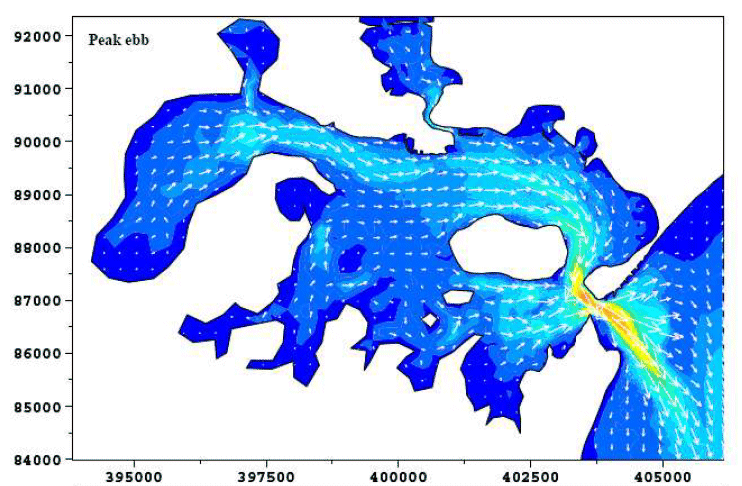
Fig 5. Tidal Flow Map of Poole Harbour at Peak Ebb (image from CEFAS)
This image from a 2009 CEFAS sanitary study of Poole Harbour shows that during the ebb tide, water is carried from Holes Bay directly to the Shore Road (Kite Beach) ocean sports area and once out of the harbour is taken along the Sandbanks beaches to Canford Cliffs before being turned back by the tide. At that time, 47,700 cubic metres of treated sewage were discharged into Holes Bay every day - the next largest discharge was at Wareham and amounted to 2,500 cubic metres per day. The study notes that:
"Faecal coliform concentrations in the effluent from Poole STW.." [Sewage Treatment Works] "..have increased since 2006. The underlying cause for the deterioration in effluent quality is not known"
The CSO discharge then exits the harbour to turn right and flow along the Studland AONB beaches and then (hopefully!) out to sea.
How much and how often?
So just how much sewage is being discharged by the CSOs, when and why? For that we turn to the figures provided by Wessex Water combined with rainfall figures provided by the Environment Agency (Bournemouth and Alderney weather stations added together so as not to miss any localised rainfall). There are clearly two separate marine environments - the Harbour and the ocean-facing beach, and within the Harbour there is Holes Bay (not a place frequented by ocean sportsmen, although there are moorings there) and Kite Beach so we have split the next part into three.
First up - here's a graph of all CSO discharges into Holes Bay over the timeframe of the SAS report (in brown), plotted against rainfall (in blue):

Fig 6: CSO discharges in Holes Bay over the timeframe of the SAS report (image copyright BeachPeople)
Secondly - here's the graph of discharges at Evening Hill which is a few hundred metres towards Holes Bay from Kite Beach:

Fig 7: CSO discharges at Evening Hill over the timeframe of the SAS report (image copyright BeachPeople)
And finally, here are the discharges from Shore Road Beach, ocean side:

Fig 8: CSO discharges at Shore Road over the timeframe of the SAS report (image copyright BeachPeople)
The SAS report states that there were 299 discharges at Shore Road beach (from the data it's clear that they are referring to the ocean side of Shore Road, and therefore CSO #15235 which runs about 500m offshore from Shore Road beach), yet we have only shown a few dozen at most on the above graph so what gives?
It all comes down to how you define a spill and that's where the waters get a little murky.
CSO #15235 is a pumped outfall and as such it can be turned on and off within a minute. Contrast that with a weir overtopping which can run for hours and you can see that we are comparing apples and oranges.
The Environment Agency try to address with Event Duration Management (EDM) - here's a cut out and keep definition for you:
Event duration measurement (EDM)
From HM Government's website Gov.uk:
"Counting spills: bathing and shellfish waters
In general, a spill greater than 50m3 is considered significant.
Count spills using the 12/24 counting method:
Start counting when the first discharge occurs.
Any discharge (or discharges) in the first 12-hour block are counted as one spill.
Any discharge (or discharges) in the next, and subsequent 24-hour blocks, are each counted as one additional spill per block.
Continue counting until there’s a 24-hour block with no discharge.
For the next discharge after the 24-hour block with no discharge, you begin again with the 12-hour and 24-hour block spill counting sequence.
And again from HM Government's website:
For storm overflows that discharge to bathing waters with a target of excellent status, the emission standard is for no more than 2 significant spills per bathing season on average.
Whether a spill is significant will be considered on a site-specific basis. In general, for design purposes, a spill greater than 50m3 is significant. "
CSO sewage discharge amounts for 2020
So by this method - a single one-minute pumped spill is counted as the same as an 11 hours weir overtopping - that's clearly not ideal when you are considering whether it's safe to swim.
Obviously to ocean sports people, the amount of sewage matters as much if not more than the duration, and technology is working to fill the gap - an in-depth article on the new technology can be found on the Water Industry Journal's website here. Here's a snippet to whet your appetite:
"Devices such as Pulsar’s dBi non-contacting ultrasonic level transducers have found a real niche in this application, with 75% of all dBi sales world-wide now going into CSO measurement for CSO and EDM schemes. Further development has led to a ‘companion’ instrument, Pulsar’s MicroFlow-i, a low power non-contacting microwave unit that sits above a channel and uses a novel spread spectrum analysis approach to measure the flow velocity."
In order to make some kind of sense of this, for the graphs I combined each day's individual spills into one total and that is what has been plotted against rainfall. It's not ideal as it hides information but it does give a broad outline good enough to answer the question "I'm thinking of swimming in the harbour - has there been a raw sewage spill recently?"
Focusing on the third graph, that of Shore Road, you can see that most CSO usage tallies roughly with rainfall and that there were raw sewage discharges a couple of dozen or so times in the year to Sept 20th 2020. As to how may discharges there were exactly - it all depends on what you want to call a discharge.
The Combined Sewage Outfall pump at Shore Road Beach was used a total of 771 times in the year to September 30th 2020. The vast majority of those discharges lasted a few minutes. The total time it ran was 3 days 3 hours 8 minutes and 40 seconds.
And that's where we hit a problem. Not all CSOs are created equal. They can have different flow rates, and given that the HM Government limits specify amounts of sewage not duration, and Wessex Water provide figures for duration, we have to dig a little deeper. We need to know rate of flow.
Buried within the permit data for each CSO are two figures expressed in terms of flow rate: Dry Weather Flow (DWF) and Pass Forward Flow (PFF). By converting both values to cubic metres per minute and finding the duration of discharge in minutes we can obtain the total volume discharged - this table is for the 2020 bathing season (May 15th to September 30th) only as that's when the Government limits apply
Update 23rd Feb 2021 - Wessex Water have provided the maximum flow rate for CSO #1535 Shore Road, as DWF and PFF rates are not suitable values to use. The table above has been updated accordingly.

Fig 9: Volume of discharge of CSO #15235 Shore Road based on DWF and PFF figures (image copyright BeachPeople)
Based on maximum flow rates:
- For the 2020 bathing season
- there were 95 separate spills of more than 200 seconds
- for spills over five minutes in duration, the number falls to 67
- there were 9 separate days where spills exceeded 50 cubic metres (totalling 14700 cubic metres between them)
- based on maximum flow rate, the total discharge of CSO #15235 for the 2020 bathing season was 14,768 cubic metres of sewage
- For the year to November the figures are 768 discharges and 67,630 cubic metres.
For a Blue Flag beach to retain its 'Excellent' bathing water quality rating, only two spills over 50 cubic metres are allowed, which implies SAS may have valid point.
..but clearly the CSO doesn't run at maximum rate all the time - the pumps need to spin up and run down, flow rate may be limited by other factors, back pressure perhaps - it's not possible to judge from that one 'maximum flow rate' figure.
But I think it may be possible to judge either by using Pulsar’s dBi non-contacting ultrasonic level transducer approach or perhaps from the current consumed by the [three phase] pump; as flow rate is probably proportional to power consumed (since volts are constant P consumed is directly proportional to I drawn), tho there is likely to be an adjustment curve needed as pump output won't be linear - the pump manufacturer can probably help on that front.
BeachPeople have been in touch with Fluke who manufacture three phase current clamps that connect to the WiFi or Cat 5e LANs and transmit the current draw data real-time. Fitting a current clamp is non-invasive as it simply clamps around the power cable in question and would provide up to the second data on which CSO is running, how fast and for how long, getting us closer to the knowing the all-important volume of discharge.
Fluke's analysis software is free for a single instance. I have enquired about prices and asked Wessex Water for their view (23rd Feb 2021).
Water quality testing in Poole Harbour - EA
Update - 5th January 2021 - the Environment Agency have responded as to why they all but ceased conducting bathing water quality sampling in 2020, claiming it is a result of Covid-19 and the protection of their staff - see Email Thread Environment Agency Explanation of Reducing Water Sampling in Poole Harbour (subscribers only).
So how has Poole Harbour become so polluted whilst at the same time established itself as an ocean sports mecca? Isn't the water tested regularly?
Well, that's the job of the Environment Agency and if you drill down into the Poole Water Quality links on the BeachPeople.club site you'll quickly see that testing for sewage has recently become sporadic at best (just three times this year compared to twenty or so tests in each year from 2016 to 2019) - here are the results for Poole Harbour Lake:
Fig 10: Environment Agency Bathing Water Tests for Poole Harbour Lake (image from the Environment Agency website)
Location of the Water Quality Sampling Points in Poole Harbour
Given that the sewage discharges into Holes Bay - you'd think that the water quality would be sampled in Holes Bay. But no, in the three or four times this year that the Environmental Agency has sampled Poole Harbour water quality this year it has done so at the following locations (harbour test locations highlighted in orange) - from the left: Rockley Park, Poole Harbour Lake, Studland Knoll House, Shell Bay North, Sandbanks Peninsula and Shore Road.
Looking at the above map and the tidal flow chart earlier, you can see how it's perfectly feasible for a sewage discharge to be timed to join an outgoing tide and miss all the Environmental Agency water sampling points, and even if it didn't the water in the Harbour has only been sampled three or four times in the whole of 2020 so it would be extremely unlikely for it to be recorded. Yet the untreated sewage can still flow into the Kite Beach area (Shore Road, Harbour Side) used by hundreds of kite surfers on a daily basis throughout the summer.

Fig 11: Environment Agency Bathing Water Quality Testing Locations Poole Harbour 2020 (image from the Environment Agency)
Back to the previous map (Fig 4.) - Shell Bay North (bottom right of the map) would seem to be the ideal point to sample for sewage (I have swum there once - never again - the mud is disgusting) but as you can see from the Environmental Agency's website they have only sampled the water there twice this year and only four times a year since 2016. That stands little chance of catching any pollution instances.
Fig 12: Environment Agency Bathing Water Tests for Shell Bay North Poole Harbour (image from the Enviromnent Agency)
And here finally are the sample dates of the offending outfall - CSO #15235 on Shore Road
Fig 13. Bathing water tests for CSO #15235 Shore Road Sandbanks (image from the Environment Agency)
..and its catchment area, according the EA website

Fig 14 CSO #15235 Shore Road Sandbanks catchment area (image from the Environment Agency)
... that's a remarkable amount of sewage discharge for a CSO that serves such a small area.
Water quality testing in Poole Harbour - Wessex Water
19th April 2021 - Although water quality sampling is the responsibility of the Environment Agency, Wessex Water have provided this map of the locations of their sampling points:

Fig 15 Location of sampling points in Poole Harbour (image provided by Wessex Water)
..along with this bit of background, reproduced in full as - as is usual with Dave Jones from Wessex Water - it's packed full of information and concise:
"Unfortunately, we do not routinely sample for general bathing water compliance (for example, bacterial levels within Poole Harbour) – this sampling has always been undertaken by the Environment Agency and we therefore do not routinely sample within Poole Harbour itself. We sample at our Water Recycling Centres which have Ultra Violet (UV) treatment as required by the Bathing Water Regulations, where the bacterial load before and after the UV treatment stage will be measured (this will be at the final effluent sampling point for relevant WRCs, such as Poole WRC). We provide summaries of the more common effluent quality sample results for our Water Recycling Centres online at https://marketplace.wessexwater.co.uk/dataset/23z6d/water-recycling-centre-influent-and-effluent-samples.
We may sample on a specific basis as a result of an incident (where suitable locations have been identified that could be used to take samples in the event of an emergency) or particular problem, but otherwise, the only other sampling is undertaken as part of our Environmental Investigations programme for specific issues.
As part of our Environmental Investigations programme, we do have several environmental investigations in and around Poole Harbour and the rivers flowing into the Harbour:
Poole Harbour Shellfish Investigation – This project will assess all the Wessex Water discharges in the Poole Harbour catchment in order to identify how the water company assets impact on the shellfish water status of Poole Harbour.
Poole Harbour N & P Investigation – This work is looking to more fully understand the Nitrogen and Phosphorus contributions from our WRCs in the Poole Harbour catchment
Holes Bay Investigation – This project is seeking to establish the load discharged of total Nitrogen and total Phosphorus from Wessex Water assets that discharge into Holes Bay. Please see notes below for the sampling points associated with this work.
Frome SSSI revised Common Standards Monitoring Guidance Investigation - This project will assess the contribution Wessex Water infrastructure and activities have on the compliance of Phosphorus, Ammonia, BOD (Biological Oxygen Demand) and DO (Dissolved Oxygen) water quality targets along the section of river designated as a SSSI (Site of Special Scientific Interest) between Dorchester and Wareham.
You can find out more about our investigations on our website at https://www.wessexwater.co.uk/environment/protecting-and-enhancing-the-environment/investigations
The sampling points associated with the majority of these investigations are either at individual assets themselves (i.e. their discharge points, or at the actual site), in rivers/streams leading to the Harbour, or on the foreshore. Our Holes Bay investigation does feature sampling points in the Harbour, but limited to the Holes Bay area. The map below shows the monitoring points in and around Holes Bay. The sample points are being tested for total phosphorus, total nitrogen, soluble reactive phosphorus, nitrate, nitrite, ammoniacal nitrogen, conductivity, pH, alkalinity, total suspended solids, iron, dissolved oxygen and temperature.
In addition to the above, other sampling may occur as part of ongoing or future evaluations of our Storm Overflows which can be classified as Frequently Spilling Overflows (FSO). In the past, our Streamclean team have also been involved with sampling to determine where there are misconnections to the surface water network, but this is again not within Poole Harbour itself, but at outfalls or manholes within our sewerage network.
As previously mentioned, other organisations such as BCP are involved with monitoring water quality within Poole Harbour. "
Sampling point 1 seems an ideal place to see what's coming out of the many CSOs in Holes bay. From a sewage discharge perspective; of that list of 13 tests that are performed, 'total suspended solids' would seem potentially helpful, but there don't seem to be any tests for e. coli etc. - this seems to be mostly about Nitrogen and Phosphates (fertiliser run off?).
It's all useful background and appreciated - but it doesn't get us much closer to knowing if the water on a given day is safe to swim in; that's the aim here.
Bathing Water Categories
According to the Environment Agency's website, bathing water is tested for E.coli and Intestinal enterococci, and the results fall into one of four categories:
"excellent – the highest cleanest seas
good – generally good water quality
sufficient – the water meets minimum standards
poor – the water has not met the new minimum standards. Work is planned to improve bathing waters not yet reaching sufficient [sic]"
In greater detail, the EA limits are as follows:
| Classification | Thresholds | Confidence level |
|---|---|---|
| Coastal Bathing Waters | ||
| Excellent | EC: ≤250 cfu/100ml ; IE: ≤100 cfu/100ml | 95th percentile |
| Good | EC: ≤500 cfu/100ml ; IE: ≤200 cfu/100ml | 95th percentile |
| Sufficient | EC: ≤500 cfu/100ml ; IE: ≤185 cfu/100ml | 90th percentile |
| Poor | means that the values are worse than the sufficient | |
| Inland Bathing Waters | ||
| Excellent | EC: ≤500 cfu/100ml ; IE: ≤200 cfu/100ml | 95th percentile |
| Good | EC: ≤1000 cfu/100ml ; IE: ≤400 cfu/100ml | 95th percentile |
| Sufficient | EC: ≤900 cfu/100ml ; IE: ≤330 cfu/100ml | 90th percentile |
| Poor | means that the values are worse than the sufficient | |
Key EC: Escherichia coli, IE: Intestinal enterococci, cfu: Colony Forming Units - this is an estimate of the number of bacteria in a sample of water. This is done by counting the number of colonies (groups) of bacteria growing on a filter through which the sample has been passed.
Effect on the local shellfish industry
Poole Harbour has [had] a thriving shellfish industry - the largest of which is Othneil's Oysters who operate from the Old Ferry, permanently moored close to Pottery Pier on Brownsea Island.
The EU banning the sale of all shellfish caught in the UK on March 26th 2021 has removed a significant market for the UK's fishermen.. this from the BBC:
"Since 1 January, UK firms have only been able to send pre-purified, ready-to-eat shellfish - accompanied with an export health certificate - to the continent.
Up until 2021, products could be purified after arriving at their destination. Shellfish caught in the cleanest waters - categorised as "class A" - can be transported without purification, but most UK coastal seas do not fall into this category.
The UK government had initially expected the restrictions to end on 21 April, but the EU says the current arrangements will stay indefinitely."
Class A
- minimum of 10 samples required per year
- 80% of sample results must be less than or equal to 230 E. coli/100g
- no results may exceed 700 E. coli/100g
Shellfish can be harvested for direct human consumption if the end product standard requirements are met.
Class B
- minimum of 8 samples required per year
- 90% of sample results must be less than or equal to 4600 E. coli/100g
- No sample result may exceed 46000 E. coli/100g
Shellfish can be supplied for human consumption after one of three processes. The options are:
- purification in an approved establishment
- relaying for at least one month in a classified Class A relaying area
- an EC approved heat treatment process
Class C
- minimum of 8 samples required per year
- All sample results must be less than or equal to 46000 E. coli/100g
Shellfish can only be sold for human consumption after completing one of three possible processes.
These processes are:
- relaying for at least two months in an approved class B relaying area followed by treatment in an approved purification centre
- relaying for at least two months in an approved class A relaying area
- after an EC approved heat treatment process
Prohibited areas
Shellfish from areas with consistently prohibited level results (greater than 46000 E. coli/100g) must not be subject to production or be harvested."
Perhaps a map showing the classification zones for the four seafoods mentioned in the EU ban would be easier to digest, so here you are:


On the 1st June 2018 the Poole Harbour shellfish beds were downgraded by the FSA (PDF 325 KB; this is the latest document on the FSA website):
"Poole Harbour - Rockley (Mytilus spp.) B54BR
A result of 54,000 was recorded from this site on 6 March 18, triggering a possible downgrade for this long-term B site. To qualify for long term B classification, sites must not have returned a result >46,000 in the last 5-year period, therefore, this site is downgraded to an annual class B and loses its long-term status. The rolling 3-year compliance with 4,600 is 87.9%, which is marginal, therefore a note 4 is added and this site will be assessed in the 2018 annual review.
Poole Harbour – Wareham Channel (Mytilus spp. Tapes spp. and C. edule). B54BS
This bed is a seasonal class B between 1 July – 28/29 February (transitional period 1 May – 30 June). 2 samples have been taken in the transitional period, which are both within class B limits,1300 on 1 May 2018 and 1700 on 24 May 18 therefore the class B season commences with effect of today’s date.
Transition period
1st May – 30th June Class B season
1st July to 28/29th February (reverting to class C at all other times)"
Effects beyond Poole Harbour
Sandbanks is a long, thin sand peninsula - if you swim from the mouth of Poole harbour north east towards Bournemouth during an outgoing tide you will notice strong warm currents streaming from the ends of a series of rocky groynes along Sandbanks Beach, which suggests there are large harbour outlets that run under the peninsula and help to empty the harbour of water (assumably to reduce the strong tidal flow through the mouth of the harbour where the ferry plies its trade).
From the tidal flows link on the BeachPeople Planning page we can see that the tide flows from the North East to the South West after high water, which is fortunate for Poole and Bournemouth beaches as that takes any sewage discharge from Poole Harbour along the Studland coast instead (although there is some swirling along Sandbanks Beach during peak ebb as shown in the blue map). Not so great for the swimmers off the Studland beaches but their numbers are a lot lower.

Fig 17: Poole Harbour Tidal Flow 2 Hours after High Water (Images British Crown Copyright 2021)
How has this happened?
In a word, profit. My first venture to Wikipedia in this article reveals the following about Wessex Water:
The company originated as the Wessex Water Authority, one of ten regional water authorities established by the Water Act 1973 which were privatised in 1989. Wessex Water Services Limited was purchased by American company Enron in 1998 for $2.4 billion and placed in a newly formed subsidiary, Azurix. Following Enron's collapse, Wessex Water was sold to YTL Power International of Kuala Lumpur, Malaysia, in 2002.
Enron. Says it all really. Effectively since 1998 the water company has been run for commercial reasons, and from a business point of view it makes sense to invest only as much as necessary to maximise profits; this approach coupled with a chronically underfunded and toothless Environment Agency has led us to the situation today where we have 42% more people than in 1973 still using the same pipes that also carry increasing levels of rainfall (for each degree rise in average temperature the air can carry 7% more water, so global warming is a factor too. The UK average temperature raised by 0.5C from 1980 to 2010 alone).
In short - where the company should have been investing in separating the sewage and rainfall flows over the last 20 years, it has instead pocketed the profit so we still have a combined sewage system than is now overloaded and discharges raw sewage into the harbour on a regular basis.
What can be done?
Separate the run-off and sewage systems
In an ideal world we would have separate sewage and rainfall systems, so that clean-ish fresh water (synthetic rubber particles from roads and nitrates from fields are all present in run-off) would enter the sea unpolluted by human sewage.
That's a huge investment - every road in the county would need to be dug up and separate pipes laid, so it's unlikely to happen.
Temporary rainwater storage
The problem is heavy rainfall overloading the combined sewage system - the rain comes from roads and roofs predominantly.
BCP has over 500,000 residents - that's a lot of homes and lot of roofs. If each home were provided a 200-litre rain butt that slowly drains into the sewage system over hours or days then that's a colossal amount of capacitance acting to slow the surge of water down to a manageable level.
Equally it serves to reduce metered water usage (watering the garden, washing the car or patio etc.) and therefore sewage bills as the two are linked. Access to untreated soft water is helpful to gardeners in a hard water area.
It seems win-win - the downside from Wessex Water's point of view is lower water bills, and the costs of the butts (£20-£30 per household retail as a one-off purchase)
Suggested to Wessex Water on the 10th June 2021
Pipe the sewage through Poole Harbour
This to me seems feasible as there are very few obstacles between the CSOs in Holes Bay and the open sea - only one in fact, the Sandbanks Peninsula, and there are already sizeable pipes underneath that.
It's a few miles of soft sand into which it would be easy to bury an extended CSO which could then emerge a long way offshore - the Harbour would immediately start to cleanse itself as there are very few other outfalls to affect it.
Improved (daily) sampling and in the right place
Looking at the maps in this way it's pretty clear that if you wanted to find pollution then the sampling point would need to be at the outlet of Holes Bay, and if you wanted to protect ocean sports people then the sampling point would be at Kite Beach (ideally at the end of the East Dorset Sailing Club pier or North Haven Yacht Club pier as they bracket the kite surfing area).
Equally if you wanted to find pollution then you would sample each day on an outgoing tide, especially after heavy rain. Stormy conditions are when many ocean sports people tend to be out on the water, unlike most beach users who prefer calmer, warmer, sunnier conditions.
..but if you didn't want to find pollution then abruptly reducing the water quality sampling rate to a few times per year and selecting places as far as you can away from Holes Bay, ideally with rivers flowing into them, would be your best option.
According to the Marine Conservation Society, Kite Beach is untested:
"Water samples are not taken at this beach because it has not been designated as a bathing water and there is no voluntary sampling.
High levels of bacteria in the water can indicate pollution from sewage treatment works or polluted rain water draining from the land."
We have of course contacted DEFRA to see if we can get Kite Beach designated as bathing waters and therefore tested.
Essentially - an independent bathing water quality monitoring station needs to be established to keep an eye on the actual sewage discharged from Holes Bay (rather than relying on those that are reported by Wessex Water) - this would ideally be carried out twice daily to catch the ebb tides. By sampling there we exclude the argument that it's ship discharge, as Holes Bay is way too shallow to accommodate any large vessels.
Hard evidence, in conjunction with the new Sewage Bill's "Polluter Pays" ethos, may yield results either through Government channels or legal ones.
More Severe Penalties
Without independent and incontrovertible proof, the polluters are able to wait a couple of tides and all evidence is lost – it’s only with hard, reliable data that the private members bill to prosecute polluters being sought by MP Philip Dunne in July 2020 stands a chance of being effective. Mr Dunne says that the bill will "introduce water firms to [the] polluter pays" concept. Next read of the Bill is January 15th 2021.
A rather telling section from the above Guardian article shows the difference between the proactive approach of South West Water and the reactive approach of Wessex Water, who feed into Holes Bay:
"A spokesperson said in 2018-20 South West Water completed an extensive programme to install event duration monitors on its 1,192 overflows.
As a result, more than 90% of these now provide data on the start and stop times of any storm water discharges. Thirty-seven overflows were being investigated in relation to their frequency of operation and potential environmental impact.
Wessex Water said it had categorised its CSOs and the information was shared when requested."
Public Notification
Most importantly in terms of public safety, all beach users should be able to determine easily (and without resort to a website) whether there has been a sewage discharge in the preceding few days. Whether this be chalk boards or monitors at key locations, "brown flags" along the prom, or a email or SMS to all interested parties, the better that people are informed, the fewer will be sick.
Wessex Water's Coast Watch System
Wessex Water use telemetry to monitor their CSOs - this from their report to us sent on April 12th 2021:
"1. We can use a telemetry signal that provides level data. If the rises above a certain value, a spill is likely to have happened.
2. We can use a telemetry signal that provides pump running data. If a pump runs, a spill is likely to have happened.
Each has problems:The level data is a good indication of a spill but sometimes sewer levels hover around a weir and it is impossible to tell if there is real 'spill over' or not.
The pump data includes short periods when pumps are turned on for maintenance or for routine 'exercise' runs to keep them healthy.
Our CoastWatch data needs on/off telemetry data to work, so our only choice is to use the pump running signals."
The outcome is a web page that shows daily spills on the 12/24 EDM basis - it isn't clear how soon after a spill starts that the web page is updated, for example:
At 05:51 on July 12 2021, #15235 Shore Road (amongst others) started to spill and we received this email from Wessex Water (amongst a couple of dozen about the pumps at various locations switching on and off) :
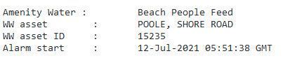
Yet - even by 12:48, some seven hours later, Wessex Water's CoastWatch website was showing no spills at that location. If you were checking to see that the water was safe to swim, you would assume that all was good despite the presence of raw sewage in the water. It isn't clear what process updates the public-facing CoastWatch system but it seems to lag so far behind events as to be no use for making decisions about water safety*
(*Update 12th July 2021: Wessex Water have said that the CoastWatch system should update automatically and that there may be a is a problem with the CoastWatch system that will be looked into by the team responsible)

Fig 19 Screenshot of Wessex Water's CoastWatch system (image from Wessex Water's website)
A possibly more reliable service is provided by Surfers Against Sewage's Safer Seas Service - the screenshot from July 12th 2021 14:08 shows pretty much the whole BCP coastline to be suffering raw sewage discharge.

Fig 20 Coastal water quality sampling points used by the SAS Safer Seas Service
A snapshot service like this is ideal for checking whether the water is safe to swim in, provided that you know to go and look. I am not sure how many of the 500,000 people that visit BCP beaches on a hot summer day know to do so. As you will see further on, BCP council have a responsibility to inform the public about sewage discharges on public beaches - BeachPeople has contacted the Councillor holding the portfolio for Environment, Cleansing and Waste for comment.
Starting today (July 12th 2021) BeachPeople will manually update an Excel spreadsheet of the sewage discharge events into Poole Harbour. It's basic now but over time it should build into a simple snapshot of which CSOs are the worst offenders (i.e. which beaches and waters are the most unsafe).
Here's the rainfall & CSO discharge graph again for Shore Road CSO #15235 but with the dates of the Coast Watch alerts added as blue dots (bathing season only).

Fig 21 Combined rainfall and CSO discharge from CSO #15235 Shore Road Beach (image copyright BeachPeople)
Local Council Responsibilities
BCP Council do have a responsibility to display information about the bathing water quality (this according to https://www.gov.uk/government/collections/bathing-waters)
"Information that must be displayed
Local councils must display information at the bathing water to show water quality during the bathing season (15 May to 30 September).
See the bathing water information and signage rules.
Each classification given to bathing waters has a symbol that councils must display.
If you’re a local council you can easily create a sign with the create a bathing water sign tool and other design tools mentioned in the guidance."
and more specifically from https://www.gov.uk/guidance/bathing-water-information-and-signage-rules-for-local-councils they should:
"Display information about pollution incidents
If pollution could affect people swimming or paddling, you must display information on both:
the nature of the problem
how long it’s expected to last
You must display information about any ‘abnormal situations’ that affect designated bathing waters. An abnormal situation is defined as:
An event or combination of events impacting on bathing water quality at the location concerned – not expected to occur, on average, more than once every 4 years.
The EA will tell you if a pollution incident has been categorised as an abnormal situation. It will also give you information about the nature of the problem and how long it’s expected to last.
You must display information about how many days the EA advised against bathing during the previous bathing season."
13th April 2021 Mohan Iyengar at BCP council has been emailed to provide information about what the council is doing to fulfil its duty in this regard.
12th July 2021 Councillor Mark Anderson, Portfolio Holder for Environment, Cleansing and Waste, contacted for comment on the pollution in Poole Harbour.
Hope on the horizon?
The Sewage Bill from Rt Hon MP Philip Dunne
The Sewage Bill was read in Parliament in the run up to covid lockdown and unfortunately ran out of time but there was some positive benefit - this quote from the linked article:
"I was delighted that on 29th March 2021 the government confirmed that it will legislate to bring in three measures at the heart of my Bill: placing a duty on government to publish a plan by September 2022 to reduce sewage discharges from storm overflows; a duty to report regularly to Parliament on progress on implementing the plan; and a duty on water companies to publish data annually on storm overflow operation." - Rt Hon MP Philip Dunne
and there might be a ray of hope, but not anytime soon..
Improved Monitoring
On the 14th July (no year mentioned but I am guessing 2020), an article on the Poole Harbour Commission website announced the following:
"..BCP Council has announced a pilot project which will utilise artificial intelligence (AI) technology to monitor, protect and improve the water ecosystem in Poole Harbour...
The new project will .. provide a network of water quality sensors to continuously monitor the harbour for real-time AI analysis. This innovative, low cost approach to environmental monitoring will enable the detection of a much wider range of physical, chemical and biological indicators within the harbour. This will help them to understand, manage and predict events such as bacterial build up, sewage, fertiliser run-off and industrial discharges, which can be harmful for aquatic ecosystems, creating a build up of algae which can be detrimental to water quality.
The project is commencing with a pilot in the Poole Park lake, which is connected by a sluice channel to Poole Harbour. With more shelter around the lake making it easier to access the AI, the pilot will utilise existing water quality data from the lake to help to train the AI ahead of its use in Poole Harbour."
There was no mention of whether the data will be made public and the location (Poole Park Lake sluice gate) is likely more about convenient access than demonstrating the existence or otherwise of heavy sewage pollution; this won't yield much value short-term so it seems sensible to rely on proven technology to monitor the sewage levels coming out of Holes Bay.
Helpful Links
HM Government Permits For Storm Overflows etc.
- includes a definition of the 12/24 method for classifying outflow events
HM Government Bathing Water Quality Explainer
- the UK Bathing Water Quality season is May to September
In The News
We cover a lot of news articles in the club's Pollution and Climate Change news pages but here are a few hopefully useful searches of the local and national press
Bournemouth Echo on "Sewage" (386 articles)
The Guardian on "Sewage Dorset" (140 results)
Updates since this article was published
I sense this list may grow as I peel the layers off this particular onion but..
- Jan 2020 - Preventing Plastic Pollution, a 14M Euro project to tackle plastic pollution, was launched. The project is led by Queen Mary University and will run until 2023. Poole Harbour is a target:
- "The project is looking at whole river catchments and developing a scalable and transferable mapping tool by gathering data on the amount and likely sources of plastic pollution in seven pilot catchments: Brest Harbour, Bay of Douarnenez, Bay of Veys, Poole Harbour, and the Medway, Tamar, and Great Ouse estuaries. The information gathered in these areas will support the cross-Channel partnerships to tackle some of the four million tonnes of plastic waste that globally enter the sea via rivers every year" (https://bit.ly/2SBr5yI)
- Jan 19th 2020, Express.co.uk "Sewage-filled rivers ‘caused oyster bug’, probe suggests"
- "A restaurant owned by celebrity chef Rick Stein was one of several caught up in the food safety crisis as diners fell ill after eating shellfish."
- "The oysters are believed to have come from Poole Harbour and a Dorset-based supplier suspended its sales for 28 days."
- "A probe by Public Health England has suggested norovirus as the suspected cause of the debilitating illness, which is not routinely tested in molluscs sold for eating."
- Rick Stein operates a shellfish restaurant that is located on Poole Harbour, metres away from Shore Road Beach (10 -14 Banks Road, Sandbanks, Poole)
- March 8th 2020 - MedPageToday.com - Covid 19 is spread by the fecal oral route.
- Summer 2020 (date TBC)
- A Poole Harbour Commission meeting revealed that the local shellfish have been downgraded in quality - likely due to the effects of pollution.
- Oct 2020 - real time 'AI' monitoring network 8eported by BCP Council to have been established in Poole Harbour
- Nov 6th 2020 - Surfers Against Sewage published a Water Quality Report
- Nov 9th 2020
- Wessex Water have agreed to provide BeachPeople with details on all sewage and mixed discharges into Holes Bay in the last 12 months (i.e. the period covered by the SAS report)
- This will take them between 20 and 40 days
- Nov 19th 2020
- The citizens who live near the heavily polluted Mar Menor lagoon in Spain are exploring the idea that the area can be deemed a legal entity in its right and thereby be protected under law.
- Dec 1st 2020 - BCP Council announce that a £2.7m nature park is to be created to offset the development around Poole Harbour - in particular nitrogen
- "BCP Council is required to ensure all development in the harbour catchment area is “nitrogen neutral” to protect it from pollution."
- "Research has found most of it is linked to agriculture but sewage treatment outflows are also contributors, despite technology being in place to limit it."
- I'm no expert in building but apart from those wonky Portaloos and maybe some fertiliser on the little squares of grass I don't think new homes generate much nitrogen on an ongoing basis. Apart from the sewage.. which is a tacit acceptance that houses around the Harbour pollute the water and the solution is a pay a fortune for a field elsewhere.
- Dorset Wildlife Trust have been emailed for comment
- Dec 2020 - Surfers Against Sewage announce #EndSewagePollution campaign - over 100 MPs put their name to the bill
- Dec 1st 2020 - Microbiological testing facilities contacted about the daily testing of the Holes Bay outflow for the presence of raw sewage
- Dec 2nd 2020 - Environment Agency contacted about water sampling in Poole Harbour
- Dec 7th 2020 - Wessex Water provide Poole-based BeachPeople.club with the following raw data over the period covered by the SAS report:
- How many outfalls there are into Holes Bay and their location and type
- The dates and times of all discharges of untreated sewage into Holes Bay over that period
- Roughly how many cubic metres of combined rain and untreated sewage was involved in each discharge
- They note that "Surfers Against Sewage (SAS) produced their Water Quality Report (2020) based on alert notifications received from water companies. This does not reflect when overflows were actually in use. Alert notifications can be triggered several times during one heavy rainfall event when an overflow might be in use. These include on/off alerts and sometimes false alarms. "
- Dec 12th 2020 - Sir Robert Syms, Conservative MP for Poole emailed about the issues
- Dec 13th 2020 - Extinction Rebellion stage protest about sewage pollution in Christchurch
- Jan 5th 2021 - Response from the Environment Agency to why the water quality sampling was all but ceased in Poole Harbour in 2020: Environment Agency Explanation of Reducing Water Sampling in Poole Harbour
- Jan 11th 2021 - Further response from the Environment Agency in which they drawn attention to the Notifications of Storm Overflow use published by Wessex Water (and used by the SAS to compile their reports), and the Agency's own Event Duration Monitoring (EDM) - a process for measuring and recording how often and for how long discharges from storm overflows occur - full transcript appended here: EA email thread.
- Jan 11th 2021 - Sewage Discharge Information for the year to October 31st 2020 re-requested from Wessex Water as data for 2016-2019 was provided
- Jan 15th 2021 - MP Philip Dunne's Sewage (Inland Waters) Bill due to be read in Parliament
- Feb 18th 2021 - Wessex Water provided Max flow rate for CSO #15235 Shore Road showing that there were 95 spills over 50 cubic metres for the 2020 bathing season
- 11th March 2021 - The Journal of Clean Water published a paper detailing how AI has been used to recognise 926 raw sewage spills from two processing plants using flow pattern analysis
- 18th March 2021 - Wessex Water suggest a meeting with all affected parties. BeachPeople to contact those and locate a venue if not Zoom-based (post lockdown lifting).
- 20th March 2021 - Operation Avengers Assemble commences - people from various affected industries have been contacted as well as Councillor Mohan Iyengar, Portfolio Holder for Tourism, Leisure and Culture for Bournemouth, Christchurch and Poole.
- 26th March 2021 - "The EU has placed indefinite restrictions on British fishermen wanting to sell live mussels, oysters, clams and cockles to its member states" - BBC News
- 26th March 2021 - BeachPeople has emailed the DEFRA Bathing Waters Team to see whether we can get the water off Kite Beach designated as bathing water (and crucially therefore tested)
- 29th March 2021 - Government measures to reduce harm from storm overflows to be made law
- 12th April 2021 - Wessex Water sent CoastWatch alarm data for the 2020-2021 period to BeachPeople and this section was added to the report.
- 13th April 2021 - Mohan Iyengar at BCP council has been emailed to provide information about what the council is doing to fulfil its duty to inform the public about sewage spills
- 1st June 2021 - The Guardian publishes data showing that the UK ranks last in Europe for water quality, and will be dropping out of the league from now on.
- 7th June 2021 - Wessex Water contacted to request the CSO discharge dataset that follows on from September 2020 up to and including May 2021
- 10th June 2021 - Wessex Water contacted to ask about whether widespread use of 200 litre domestic water butts to slow down the surge of rainwater into the sewage system is a viable option.
- 27th June 2021 - The Atlantic published an article suggesting that "The federal government should also be proactively monitoring wastewater for signs of an emerging virus, not relying on people to volunteer for testing" - Ralph Catalano, a public-health professor at UC Berkeley.
- 29th June 2021 - BeachPeople tour of Othneil's Oyster Farm Poole Harbour by the owner Gary Wordsworth.
- 6th July 2021 - Poole Harbour Nitrate Management Scheme contacted about farm land run-off.
- 7th July 2021 - Article on polllution in the ecosphere from illicit drugs (meth primarily) carried in human sewage via treatment plants, CSOs and run-off from land fertilised with human sewage.
- 9th July 2021 - BBC article detailing a £90M fine - the largest ever by the Environment Agency - against South West Water for discharging raw sewage in times of low rainfall
- 12th July 2021 - Wessex Water informed that their CoastWatch system isn't reflecting the spills reported by their email alert stream following heavy discharges from Shore Road (amongst other CSOs).
- 12th July 2021 - Councillor Mark Anderson, Portfolio Holder for Environment, Cleansing and Waste, contacted for comment on the pollution in Poole Harbour.
- 13th July 2021 - George Monbiot contacted following his article in the Guardian about corporate pollution of our rivers and coastal waters.
- 21st July 2021 - Dorset echo reports that Poole Harbour was closed to fisheries due to recent human sewage pollution by Wessex Water - fishermen were ordered not to catch.
- 13th August 2021 - Southern Water subject to a potential buyout following record fines for sewage discharge
- 15th August 2021 - Bournemouth Council react to sewage pumping off Boscombe Pier
- 2nd Sept 2021 - Wessex Water Sewage Treatment (Water Recycling) Plant tour and meeting
- 21st Sept 2021 - Wessex Water Overflow (wet well and storage) visits - 3 hours with 33 staff.
- 22nd Sept 2021 - project started following a year of research and two detailed meeting with Wessex Water to discuss the problem
- Leaflet quotes requested
- £79/1000 @120gsm
- DEFRA contacted to commence the process
- Shellfish industry contacted to gauge support
- Leaflet designed, 250 copies printed and distributed to homes and businesses in the Kite Beach area
- Leaflet quotes requested
- 28th September 2021 - 250 leaflets distributed in the Elms Estate in Parkstone Yacht Club and South Deep
- 6th October 2021
- BCP Councillors This email address is being protected from spambots. You need JavaScript enabled to view it. This email address is being protected from spambots. You need JavaScript enabled to view it. and This email address is being protected from spambots. You need JavaScript enabled to view it. emailed to confirm BCP's support for the designation of Kite Beach as bathing water by Defra.
- This email address is being protected from spambots. You need JavaScript enabled to view it. also contacted as the BCP's responsibility ends and PHC's starts where the pavement ends and the beach begins.
- Bournemouth Echo Editor This email address is being protected from spambots. You need JavaScript enabled to view it. emailed, asking the paper to help promote and ideally champion the issue.
- 8th October 2021
- Cobbs Quay Berth Holders Association contacted
- Cobbs Quay Marina (MDL Marinas) contacted
- North Haven Yacht club contacted
- East Dorset Yacht club contacted
- This email address is being protected from spambots. You need JavaScript enabled to view it. contacted
- Salterns Marina contacted
- Sandbanks Community Group contacted
- CEFAS reports on Poole Harbour (2009 & 2016) worked through
- Notes are here
- CEFAS & NHYC contacted about sampling location
- 28th October 2021 Response from Sir Robert Syms MP
- 3rd November 2021 Response from Wessex Water
- 4th November 2021
- This email address is being protected from spambots. You need JavaScript enabled to view it. contacted due to lack of resonse to date from other councillors
- PHC contacted again - this time FAOThis email address is being protected from spambots. You need JavaScript enabled to view it.
- ..both are to find out if their relevant organsations will support or block the designation of Whitley Lake as a Bathing Water
- 8th November 2021 - MPs pass a modified version of the Duke of Wellington's Sewage Bill after MP Philip Dunne supported it
- 15th November 2021 - Microtech Water Testing Lab contacted for pricing, North Haven Yacht Club & East Dorset Yacht Club contacted to request access to their piers for sampling in the winter.
- 16th November 2021 - Dorset Oysters recall products due to sewage pollution
- November 2021 - Surfers Against Sewage release their annual sewage report covering 2021 - download the PDF here.
- 22nd December 2021 - FT reveals the lack of investment in the nation's sewage infrastructure since privatisation
- 4th January 2022 - BeachPeople.club starts sampling the water at Kite Beach for pollution - more here
- 10th January 2022 - Exeter University announces the results of a study about the harmful Vibro bacteria being found in Chichester Harbour as well as Whitstable and Osea. "Increasing abundance and diversity of Vibrio bacteria creates health risks not only for people eating seafood, but for those using the sea for recreation purposes – either due to swallowing infected seawater or from the bacteria entering exposed wounds or cuts."
- 11th January 2022 - Exeter university contacted about working together on their UK Vibrio study
- 12th January 2022 - Discussion with Doctor Sariqa Wagley about Vibrio in UK waters - her research paper can be found here
- 13th January 2022 - MPs demand that each Water Company designate a stretch of river to be a Bathing Water by 2025
- 24th January 2022 - Ringwood Flood Warden Cllr Gareth Deboos resigns over sewage pollution levels in the river Avon by Wessex Water
- 26th January 2022 - The Good Law Project appeal the decision to allow United Utilities to be exempt from prosecution for polluting the Manchester Ship Canal
- 31st January 2022 - BCP & Wessex Water Overview & Scrutiny Meeting 2pm Civic Centre, Poole BH15 2RU. BeachPeople will attend but were unable to table questions.
- "The Overview and Scrutiny Board are asked to consider information presented from both the Environment Agency and Wessex Water regarding issues around water pollution in the BCP area – including Poole Harbour, Christchurch Harbour, the Rivers Stour, Avon and Piddle and Poole Bay coastal outflows. The purpose of this item is to gain a greater understanding of the issues involved and consider the action being taken to address this." Wessex Water presentation PDF.
- 15th Feb 2022 - Dorset Farmers take responsibilty for nitrate pollution in Poole Harbour. "
The amount of nitrogen entering the harbour has more than doubled, from around 1,000 tonnes/year in the 1960s to around 2,300 tonnes/year now. As a result, the harbour’s mudflats have become covered in green algae, which has smothered sea grass and saltmarsh, impacting on wetland birds and other ecosystems and wildlife.
Now local farmers in the Poole Harbour catchment are aiming to become some of the most nitrogen efficient in the UK. They are taking on the responsibility of reducing their nitrogen losses from their soils to a point that will not harm the environment and are developing a nutrient management scheme to meet their ambition."
- 23rd Feb 2022 - Poole Harbour Commission (PHC) state they will not object to BeachPeople's campaign to have Whitley Lake, Kite Beach Sandbanks designated as a Bathing Water by Defra (so that it tested for sewage by the EA 20 times per season)
- 13th April 2022 - BCP Council Cabinet Meeting: BCP Supports BeachPeople's Whitley Lake Campaign
- 9th May 2022 - The BeachPeople Whitley Lake Campaign gets a mention in the Bournemouth Echo courtesy of Councillor Mark Anderson
- 18th October 2022 - The BeachPeople aplication for designation (V2) was submitted to, and accepted by Defra.
- 8th November 2022 - BeachPeople provided the following update to BCP Council at their full cabinet meeting:
- [Re. BeachPeople’s application to have Whitley Lake, Sandbanks designated as a bathing water :
The data collection phase is now complete and the report has been submitted to Defra.
Numbers exceeded 400 on several occasions.
Defra asked for further detail on what facilities there are that promote bathing and Councillor Mark Anderson provided detail to BeachPeople on BCP’s future plans; Version 2 of the report was then sent to Defra.
If Defra accept the application has merit then it will now go out to national consultation – major stakeholders include BCP and PHC.
BeachPeople thanks Cllr Mark Anderson for his continual support]
- [Re. BeachPeople’s application to have Whitley Lake, Sandbanks designated as a bathing water :
- November 2022 - Surfers Against Sewage annual water quality report published
Images and text obtained from UK government departments (CEFAS, EA etc) are included subject to the Open Government Licence for Public Sector Information
BeachPeople has a range of memberships ideal for Sandbanks locals to city-stranded ocean spirits who just want to connect, especially in the seemingly endless UK winters. But our big drive is to stop the raw sewage pollution of Poole Harbour and the beaches from Christchurch down to Swanage by Wessex Water.
BeachPeople is the only organisation regularly sampling the water downstream of the array of Combined Sewage Outfalls in Holes Bay for E. Coli and Enterococci. We currently focus on Kite Beach, Whitley Lake as it's used by thousands of people throughout the year. The lab work is costly and funded entirely by private sponsors - if you would like to contribute please see our Sponsors page here.
We are also working to have Kite Beach designated as a Bathing Water so that it is sampled 20 times per year by the EA - email This email address is being protected from spambots. You need JavaScript enabled to view it. to join our mailing list and be kept up to date.
© BeachPeople 2020