edition.cnn.com/2021/04/13/weather/2021-atlantic-h…
The 2021 Atlantic hurricane season runs from June 1 to November 30. The areas covered include the Atlantic Ocean, Gulf of Mexico and the Caribbean Sea.
The National Weather Service defines a hurricane as a "tropical cyclone with maximum sustained...edition.cnn.com/2021/04/13/weather/2021-atlantic-h…
The 2021 Atlantic hurricane season runs from June 1 to November 30. The areas covered include the Atlantic Ocean, Gulf of Mexico and the Caribbean Sea.
The National Weather Service defines a hurricane as a "tropical cyclone with maximum sustained winds of 74 mph (64 knots) or higher."
Hurricanes are rated according to intensity of sustained winds on the Saffir-Simpson Hurricane Wind Scale.
The 1-5 scale estimates potential property damage.
A Category 3 or higher is considered a major hurricane.
Show more
In the wake of hurricane Ida hitting the Gulf coast sixteen years to the day that Katrina did, the Conversation has a really informative set of articles on where the current thinking is on hurricanes.
Check out how warm the water is out there!
theconversation.com/hurricane-ida-4-essential-read…
Heres a handy explanation of why the weather seem to be wetter these days
"The frequency and intensity of heavy precipitation events have increased over most land areas. This is because the warmer atmosphere is able to hold more moisture — about 7% more for each additional degree of temperature —...Heres a handy explanation of why the weather seem to be wetter these days
"The frequency and intensity of heavy precipitation events have increased over most land areas. This is because the warmer atmosphere is able to hold more moisture — about 7% more for each additional degree of temperature — which makes wet seasons and rainfall events wetter."
Plus
"The IPCC finds Earth’s global surface temperature warmed 1.09℃ between 1850-1900 and the last decade."
Seven percent increase in most things is enough to notice. That's 35p on a pint for example.
Maybe summers like this will become the norm, tho it does seem odd that we can put three of our worst billionaires in space (they found a way back sadly) and pipe oil from miles underground yet we can't move fresh water from where towns are flooding to where it forests are on fire.
theconversation.com/this-is-the-most-sobering-repo…
Show more
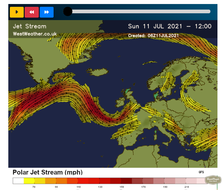
There's a useful Jet Stream forecast at www.westweather.co.uk/jetstream that goes up to ten days forward.
Equally interesting is the description below of the mechanics of a Jet Stream, and especially how Rossby waves can result in e.g prolonged wet summers whilst people are dying of heat just...There's a useful Jet Stream forecast at www.westweather.co.uk/jetstream that goes up to ten days forward.
Equally interesting is the description below of the mechanics of a Jet Stream, and especially how Rossby waves can result in e.g prolonged wet summers whilst people are dying of heat just across the Channel in usually nice-to-go-places like Spain and Italy. And also France.
In a nutshell - the Jet Stream is a band of fast moving air that blows from west to east - it separates the cold grey miserable polar air from the warm, continental 'just baked croissant'-flavoured stuff.
The stream itself wanders slowly north and south across the UK - when it's south of us we are stuck in miserable grey days of Old London Town, when its to the north we get our flipflops out. So far so simple.
But it's not the kind of steady stream that your Doctor asks for - ripples move from the east to the west that force it up and down the country temporarily - these are called Rossby Waves and they are independent of the speed of the oncoming stream..
If the Rossby wave speed matches the opposite-flowing Jet Stream speed then conditions become static and we may see either a prolonged heatwave or wet season.
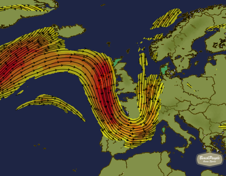
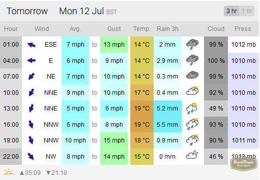
A useful example is tomorrow 9pm's Jet Stream forecast (second image) vs XC Weather forecast (third image). The Jet Stream has completely looped south around the bottom of the country, leaving us in a pool of unsettled 'Polar' weather which persists until Thursday.
As to how accurate the predictions are I have no idea, though most likely the further out they get the less accurate they become.
Understanding the mechanics of UK weather may not make you feel any happier about our stolen summer, but it is some comfort to know what to blame.
..
Show more
For anyone interested in watching the Blood Moon Eclipse today (visible in the Southern hemisphere), The Griffith Observatory has a live stream on YouTube here
m.youtube.com/watch
Streaming starts at 09:44 BST, the Moon moves into the Earth’s penumbra at 10:45am BST, and moves into the Earth’s...For anyone interested in watching the Blood Moon Eclipse today (visible in the Southern hemisphere), The Griffith Observatory has a live stream on YouTube here
m.youtube.com/watch
Streaming starts at 09:44 BST, the Moon moves into the Earth’s penumbra at 10:45am BST, and moves into the Earth’s umbra at 12:11 BST.
Show more
weather.mailasail.com/Franks-Weather/How-Waves-And…
Frank's Weather has some useful background on waves
"There are requests from time to time for more detailed forecasts of sea conditions. I have been asked why the UK does not include swell height in its marine forecasts.
Here, I try to explain...weather.mailasail.com/Franks-Weather/How-Waves-And…
Frank's Weather has some useful background on waves
"There are requests from time to time for more detailed forecasts of sea conditions. I have been asked why the UK does not include swell height in its marine forecasts.
Here, I try to explain how waves and swell are formed and why sea state can be so variable in space and time.
Sea state depends on wind, current, coastal topography, the depth and nature of the sea bed. A sailor should be able to predict, qualitatively, how rough the sea is likely to be using a local wind forecast, tidal atlas and charted warnings of overfills and eddies. As in all of sailing, predictions will improve with experience gained and lessons learned. It is my belief that sea state near the coast cannot usefully be predicted on the space/time scales of an inshore waters or offshore forecast.
Swell originates beyond the areas of local forecasts and varies depending on its source, so it is hard for a sailor to predict. It can be a hazard at some harbour entrances and, in those cases, swell forecasts for the coasts affected are valuable. "
Show more
royalsocietypublishing.org/doi/10.1098/rsta.2017.0…
Particles in the water actually drift towards the waves, called Stokes Drift, discovered in 1847.
This paper discusses the physics behind the phenomenon
www.ranker.com/list/10-biggest-deadliest-most-dest…
Hard to a hurricane called Fifi seriously - perhaps that was a factor in the number of lives lost..
www.theguardian.com/world/2020/dec/18/cyclone-yasa…
"The government had estimated that 850,000 people – 95% of Fiji’s population – would be directly affected by the cyclone."
"The cyclone is another blow to the country’s tourism-reliant economy, already devastated by pandemic shutdowns which have...www.theguardian.com/world/2020/dec/18/cyclone-yasa…
"The government had estimated that 850,000 people – 95% of Fiji’s population – would be directly affected by the cyclone."
"The cyclone is another blow to the country’s tourism-reliant economy, already devastated by pandemic shutdowns which have caused tens of thousands of job losses. Fiji’s economy has shrunk more than 20% this year due to the pandemic."
Show more
www.theguardian.com/world/2020/dec/16/cyclone-yasa…
Even if the two storms don't combine Yasa alone is devastatingly powerful - the Guardian seems remarkably sanguine about it given the wind speeds and its slow moving nature (which means inundation for towns by cobtinual heavy rainfall).
www.theguardian.com/world/2020/nov/10/devastating-…
"The annual record for the number of major storms forming in the Atlantic has been shattered, with Subtropical Storm Theta becoming the 29th named event in a hyperactive hurricane season.
The US National Hurricane Center said the development of...www.theguardian.com/world/2020/nov/10/devastating-…
"The annual record for the number of major storms forming in the Atlantic has been shattered, with Subtropical Storm Theta becoming the 29th named event in a hyperactive hurricane season.
The US National Hurricane Center said the development of Theta, currently churning through the heart of the Atlantic, had broken a record that stood since 2005, when there were 28 named storms. "
Show more
-
Bad news sells so the press tend only to publish the worst of events, and in such a complex global weather system there are plenty of them.
That said, hurricanes in the Atlantic can mean good waves at Bournemouth Pier so it's not all bad ..
-
Category
Website -
Created
Tuesday, 10 November 2020 -
Page admin
admin


